Public comment is open until Feb. 14 for a major project in the Ely area.
The U.S. Forest Service's Fernberg Project proposes management activities for Wildland Urban Interface risk reduction in an area surrounded by the Boundary Waters Canoe Area Wilderness on three sides. Current vegetation conditions are not well suited to thrive, given future insect and disease outbreaks, wildfires, and changing climate conditions.
Draft Environmental Assessment (EA) documents for the Fernberg Project are available for public review and comment for 30-days, through February 14, at the project page link: https://www.fs.usda.gov/project/superior/?project=65214
“The Fernberg Project is focused on creating resilient forests while protecting lives, private property, and firefighter safety,” said Aaron Kania, Kawishiwi District Ranger, Superior National Forest, “The project was developed in collaboration with the residents of Ely, our partners and the Tribal Bands but it’s important that everyone be allowed to provide their voice and submit a comment.”
Proposed actions along the BWCAW boundary would be implemented to achieve the objectives and desired conditions, such as: protecting lives and private property, firefighter safety, allowing lightning fires in the BWCA to play their natural role when appropriate, promoting forest conditions that are resilient to future wildfires, and creating a mosaic of fuel treatments that decrease future wildfire risk. This Wildland Urban Interface risk reduction project would include prescribed burning and related activities inside the BWCA. Proposed actions would also retain the high recreation value and wildlife habitat, both inside and outside of the BWCA.
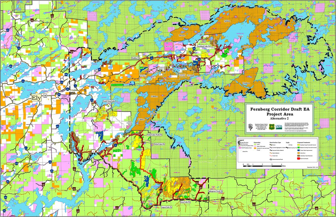
The Fernberg Project road corridor stretches 15 miles east of Ely and is bound on three sides by the BWCA. The project includes mixed ownership encompassing approximately 174,873 acres including approximately 84,000 acres inside the BWCA. Inside the BWCA, the initial proposed actions would include prescribed burning and related activities on approximately 26,000 acres with the remaining 58,000 acres being contingency areas for the prescribed burn units. The Forest Service has been working with the Tribal Bands, Minnesota Department of Natural Resources, Dovetail Partners and other partners on this project.
Tribal Chairs for the Bands of Lake Superior Chippewa signatory to the 1854 Treaty (Bois Forte, Fond du Lac, Grand Portage) have been collaborating with and consulted on this project since August 2022. Overall, tribal staff and resource specialists are reportedly supportive of the project concept.
The draft EA and supporting documents will be available along with the public outreach and scoping documents on the project website: Fernberg Project.
The Fernberg Corridor interactive map can be found here: https://www.fs.usda.gov/project/superior/?project=65214
The Kawishiwi Ranger District will host the following for the Fernberg Project:
- Virtual Open House, February 4, 2025, from 4-6pm CT, via Microsoft Teams. Virtual Open House links are available on the project page link above.
- In-person Open House, February 5, 2025, 4-6pm CT, where the public will be able to review the Fernberg Corridor Project Draft Environmental Assessment documents and maps with staff. The Kawishiwi District Office is located at 1393 Highway 169, Ely, MN 55731, call for directions 218-356-7600
