

A storm that dumped up to eight inches of rain Tuesday caused major damage to area roads.
At one point three of the ways to leave Ely were closed including Highway 1 south of the airport, Highway 169 between Tower and Virginia and the Echo Trail. As of Thursday, only Hwy. 169 had been reopened.
“I spoke with the Governor this evening and he assured me that he’ll do all he can to help the people of this devastating flood,” State Rep. Roger Skraba (R-Ely) said Wednesday night.
“All the State agencies have been alerted that flooding has occurred, now we just have to document and ask the State for disaster help,” said Skraba.
MnDOT announced Wednesday that Highway 1 between Pyhola Road and Little Lake Road (six miles east of Ely) had washed out and a detour was in place.
For people who live on North Arm Road, they have been unable to get out due to two areas washed out, one of which is over 20 feet deep and 40 feet long where half the road is gone.
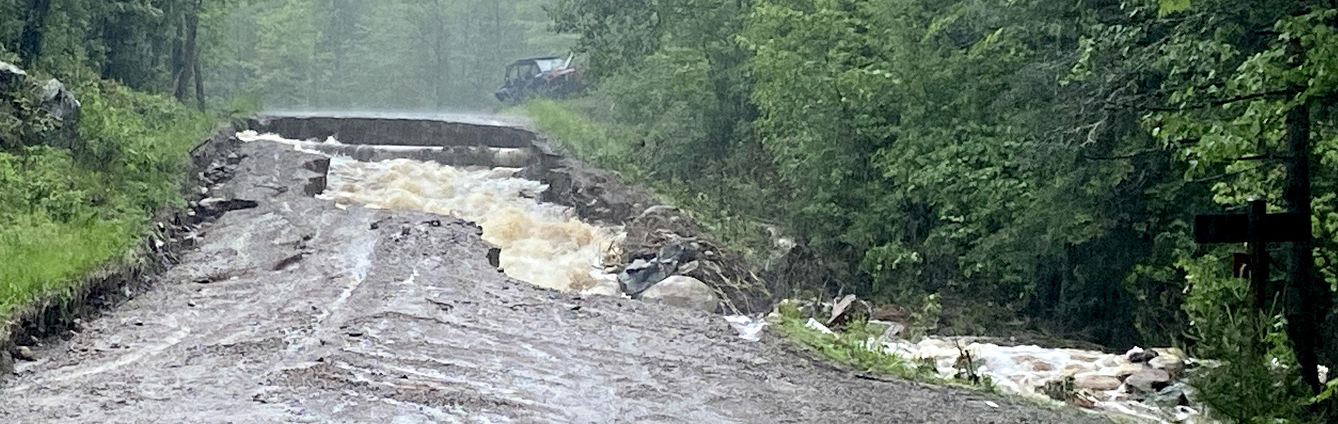
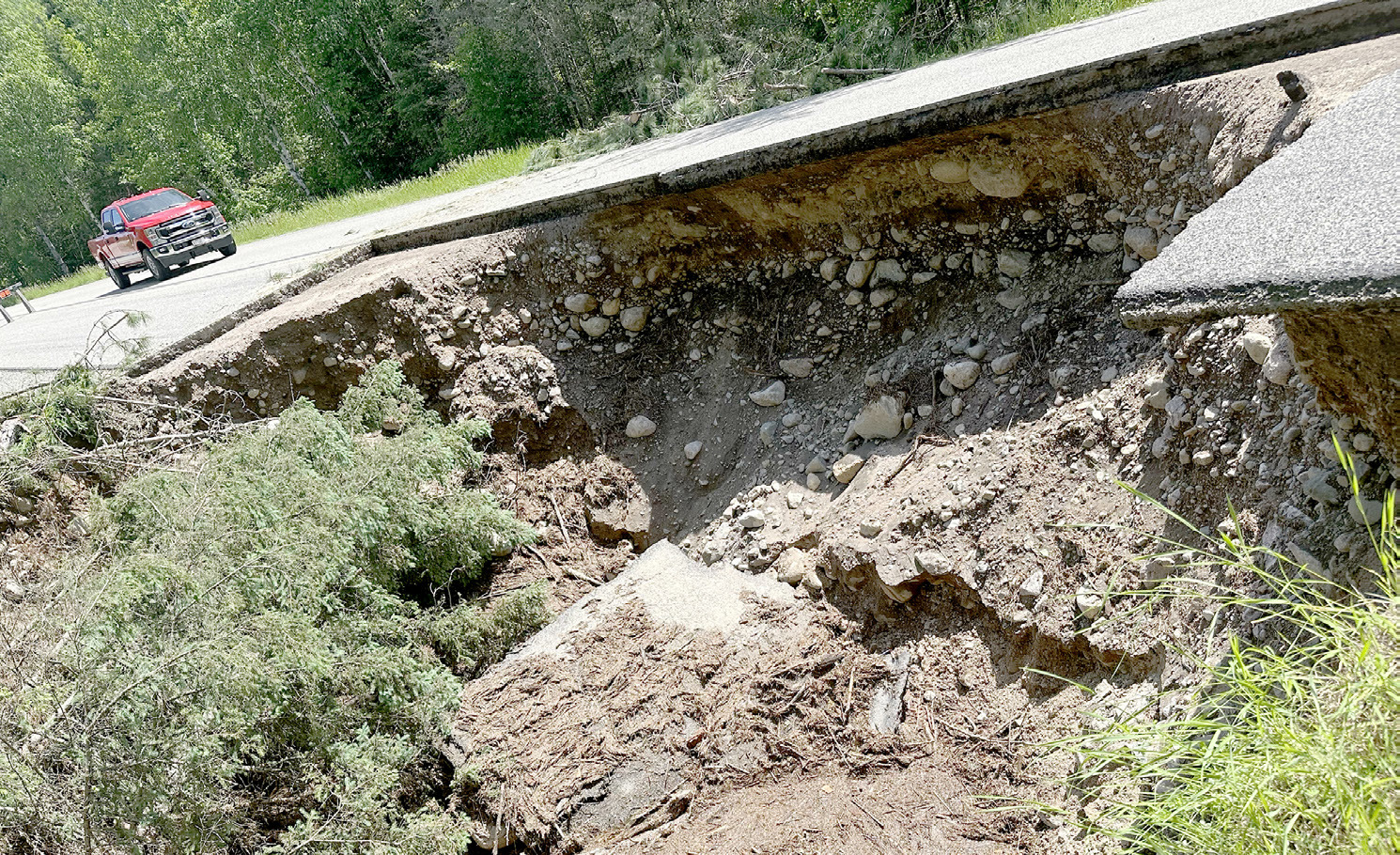
ABOVE - North Arm Road’s second washout from the June 18 storm. Photo by Emily Weise. BELOW: The North Arm Road first washout with collapsed the road when a 48-inch culvert wasn’t able to transport up to eight inches of rain. Photo courtesy of Morse-Fall Lake Fire Department.
“You want to know the scary part? I was on the road at 4:30 p.m. on Tuesday right before it washed out,” said St. Louis County’s Tom Erchull. “I banged on the door at one place and told them if they wanted to get out they needed to leave right now. Turns out the only had seconds because when I left I barely made it out. I was worried I damaged the truck because the road was so washed out already at the second washout.”
The two missing sections of North Arm Road won’t likely be replaced until this weekend at the earliest. The Echo Trail was due to open Thursday night.
“It’s rough in spots but you should be able to get through,” said Erchull. “We’re starting on North Arm (Friday) and we hope to have one lane open but it might not be until next week. That first washout is a big deal.”
Erchull said he was in contact with the National Weather Service after tornado warnings were issued for areas north of Ely.
“I asked if we could go up the Echo Trail and they told me not to at the time because there was another cell coming,” said Erchull. “We didn’t know if there really was a tornado or not.”
The St. Louis County board held an emergency meeting on Thursday morning to pass a resolution to declare a State of Local Disaster, due to high amounts of rainfall received on June 18. The county said already saturated ground from continued recent rainfall is causing flash flooding in St. Louis County.
Roads that were closed due to washouts include the North Arm Road with two culverts, including one four feet in diameter, being impassable. The Grassy Road was also being repaired due to flooding. Cars at the former Chainsaw Sisters Saloon parking lot were waiting for campers to return from BWCA trips. The road for them to get out was being worked on at press time.
The heavy rainfall on already saturated ground has led to road and culvert washouts throughout the county.
The northern third of the county appears to have sustained the most rain and resulting damage. At one point 43 county roads were closed, 32 of which were in were northern portion of St. Louis County.
Meanwhile, the St. Louis County Sheriff’s Emergency Management Division is in communication with local jurisdictions to begin the process of gathering damage assessment estimates. The St. Louis County Board’s disaster declaration was a necessary step for the county to seek funding assistance from the state and FEMA on behalf of itself along with cities, townships, unorganized areas and public utilities within the County.
St. Louis County Public Works crews were assessing infrastructure damage and have begun making repairs, with particular focus on re-opening roads that have left people without access to or from their homes. Most notable is Mud Creek Road northeast of Lake Vermilion, where water levels remain too high to attempt repairs. The Sheriff’s Office has made contingency plans should anyone on this road need emergency assistance.
Several entry points were inaccessible as of Wednesday.
“As a result, BWCAW permits cannot be issued for these entry points at this time. Individuals with BWCAW permits reserved through June 22, are being notified directly of cancellation,” a Forest Service news release stated. “We will reassess conditions and access routes each day and determine if the length of BWCAW permit cancellations needs to be extended.
The entry points currently inaccessible where permits have been cancelled and suspended include:
• Slim Lake Entry Point #6 inaccessible due to washouts on the North Arm of Burntside Road.
• Big Lake Entry Point #7 inaccessible due to washouts on the boat access road.
• Stuart River Entry Point #19 inaccessible due to the east Echo Trail closure and fallen trees.
• Angleworm Lake Entry Point #20 and Angleworm Trail Entry Point #21 inaccessible due to the east Echo Trail closure and fallen trees.
• Mudro Lake Entry Point #23 inaccessible due to a washout on the Grassy Road.
• South Hegman Lake Entry Point #77 inaccessible due to the east Echo Trail closure and fallen trees.
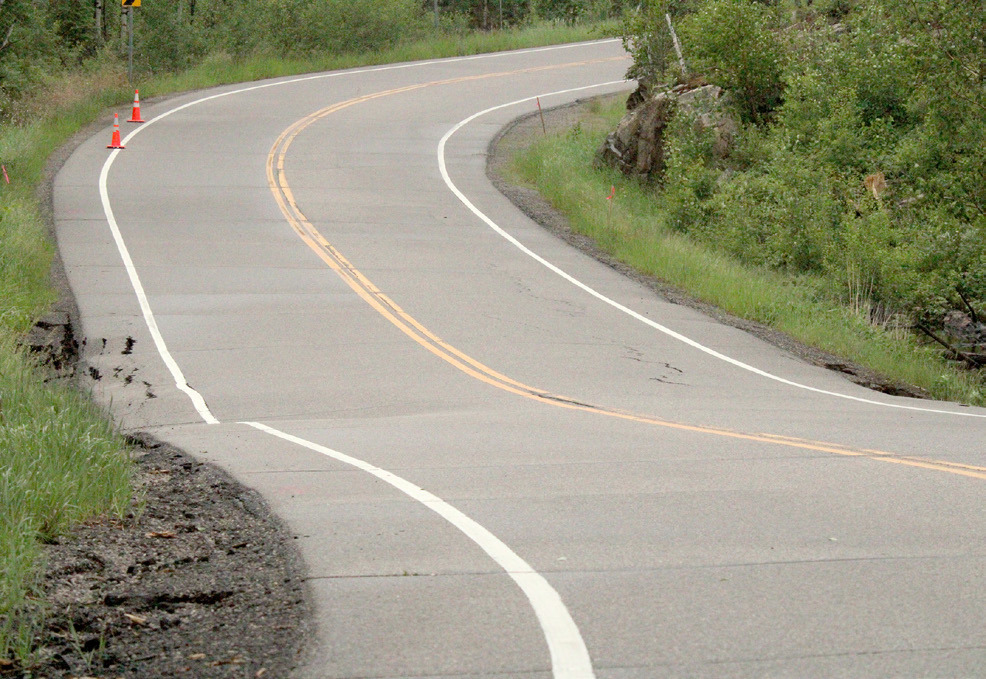
CLOSED to traffic was this section of Highway 1 two miles south of the Ely airport. The road structure was compromised from the June 18 storm. A detour is in place using the Blueberry Road to Babbitt and across a dirt road to Highway 1. Other sections of Hwy. 1 were damaged as well. Photo by Ann Weckman-Folz.